MAP+: Tailored WebGIS for your requirements
MAP+ web GIS transforms geospatial data into custom solutions that are precisely tailored to your requirements. Create individual applications for municipalities, engineering firms, or companies – intuitively, flexibly, and centrally controllable. With freely configurable interfaces, intelligent user management, and powerful analysis and reporting functions, every task can be carried out efficiently and transparently. MAP+ makes geospatial data a tool that really helps your team.

Digital geoinformation for a modern administration
Municipalities are facing growing demands: increasing transparency, more efficient processes and sound decision-making bases for politics and administration. Our WebGIS supports you in the central management of geodata, intelligent analysis and intuitive provision. Whether it is real estate/land register, building planning, infrastructure management, utility networks, energy or citizen information - all relevant information is available web-based, securely integrated and always up-to-date. This is how you create a reliable data basis, reduce administrative effort and drive the digital transformation of your municipality in a targeted manner.
Your data in the center - Your municipal WebGIS
- Integration of your own data: Utilities, infrastructure, environment, energy and administrative data are managed centrally and intelligently linked.
- Seamless geodata integration of external sources: Integration of cantonal and federal geodata (e.g. official surveying, ÖREB cadastre) as well as integration of existing specialist applications (see details below).
- Automatic updates: Regular, system-supported updates of your data, data from official surveying and other official sources - for consistently consistent and up-to-date inventories.
- Secure hosting in Switzerland with OpenSource components
Basic geodata - constantly up-to-date and automatically prepared
MAP+ bundles all geodata relevant for population, municipalities and specialists - directly from official geodatasets or prepared and extended by us with quality assurance.
- Official surveying (updated daily): Land parcels, planned buildings, owner information, ÖREB cadastre, addresses, place names and more
- Urban planning: Building zones, zoning plans, general development plans (GGP), general accessibility plans (GEP), regional development plans
- Environment: Federal inventories, natural hazards, water protection, groundwater
- Extended perimeter: Official surveying - supplemented by all federal and selected European data
You will be able to access consistent information across municipalities from a single application.
Federal data - intelligently integrated and improved
The federal government currently provides almost 1'000 geodata topics. We have selected the most relevant content, integrated it seamlessly and in some cases processed and enriched it.
- Building and dwelling register (GWR): Over 3 million data records with optimized display and extended query options
- Heating sources of buildings: Visualization of energy and heat sources
- Ground data: Height queries, relief visualization, contour lines at 0.5 m intervals, slope gradients
- LUBIS aerial photography collection: Around 500,000 analog aerial photographs (color, infrared, black and white) and terrestrial images - specially prepared for MAP+
- Historical aerial photographs (swissimage): Time travel from 1946 to the present day
- Solar suitability: Potential analysis for roofs and facades
- Mobile phone masts (3G/4G/5G): With performance data
- Cultural heritage protection inventory (ISOS): Protected townscapes at a glance
- And much more: Discover the variety of available data directly in the portal.
European data sources - continuously updated
- OpenStreetMap: Weekly updated points of interest (POI)
- Beer Me! Database: International brewery data - including regional specialties such as Pacific and Birraria Poschiavina
- Hut and mountain lists: Carefully curated sources from the Alpine region
- Webcams: Current images via Windy
- And many more topics: Go on a digital discovery tour.
Last but not least, our claim: cartographic perfection
We develop maps that impress with their precision, clarity and design quality. Every project is implemented with the utmost care - from the data basis to the visual design. We combine state-of-the-art WebGIS technologies with sound cartographic expertise. Our aim is solutions that meet the highest technical and aesthetic standards. The result: maps that inspire trust and quality that is visible - for sustainable success.
www.mapplus.chMAP+ APPLICATIONS
Examples of MAP+ realized applications
With MAP+, you can realize individual applications in the shortest possible time - flexibly, efficiently and precisely tailored to your needs. Whether through our experienced team or independently by your specialist departments: MAP+ provides the technological basis for fast and sustainable solutions. Below is a selection of successfully implemented applications and data integrations with MAP+. In addition, numerous other solutions have been realized, including:
- Cemetery administration
- Urban furniture
- Water drainage plans
- Construction site coordination
- Building permits
- Green spaces, flowerbeds
- Integration 3D Mobile Mapping: Google StreetView, Infra3D, Orbit GT 3D Mapping
- MAP+ 3D
MAP+ - your platform for flexible, future-proof specialist applications.
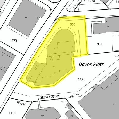
PROPERTIES
In MAP+, you can search for and filter property owners. This makes it much easier to identify properties in a targeted manner and to assign them. Administration processes such as building applications, planning or notifications are made more efficient as the persons affected can be quickly identified. It also improves transparency in property ownership and supports informed decisions in spatial planning and project development. Links to the ÖREB cadastre, cross-references with addresses and zones, etc. are also provided.
Source: Darnuzer Ingenieure AG, Davos
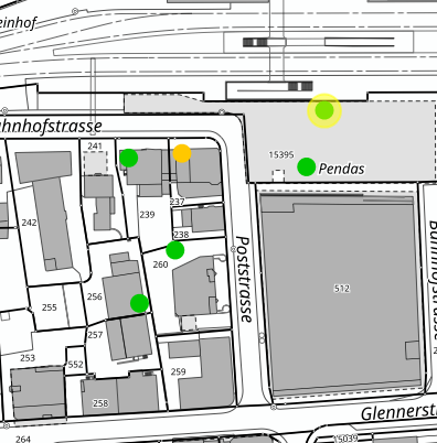
BUILDING PERMITS
The visualization, processing and management of building permits in MAP+ enables a direct spatial assignment to the properties affected. The linking to documentation such as plans, permit decisions or conditions means that all relevant documents can be accessed centrally and digitally. An integrated history shows previous applications, changes or completed procedures, thus creating transparency in the development of a property. This facilitates administration processes, improves the traceability of decisions and supports efficient building and spatial planning.
Source: Cavigelli Ingenieure AG, Ilanz
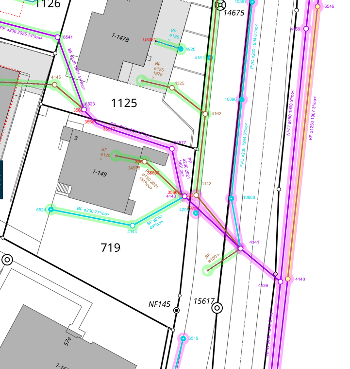
WASTE WATER NETWORK
Keep track of all the networks in your municipality - for water, waste water, district heating, electricity, gas etc. - directly in your WebGIS. Example waste water: All pipes, manholes and connection points are visualized and can be retrieved at any time. Maintenance, repairs or new installations can be planned specifically and priorities set efficiently. With integrated pipe inspections and film recordings (TV inspections), you can accurately document the condition of the pipes. Early detection of damage or conflicts between pipes saves costs and minimizes interruptions for residents and businesses.
Source: Darnuzer Ingenieure AG, Davos
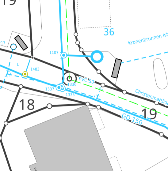
WATER SUPPLY NETWORK
Keep track of the water supply network in your municipality - for water, waste water, district heating, electricity, etc. - directly in the WebGIS. Example Water: All pipes, connections, hydrants, pumping stations, etc. are visualized, so that maintenance and repairs can be planned efficiently. Early detection of leaks or damage saves costs, reduces downtime and ensures a reliable water supply for the population. This increases the operational reliability, efficiency and sustainability of your water supply.
Source: Geozug Ingenieure AG, Baar
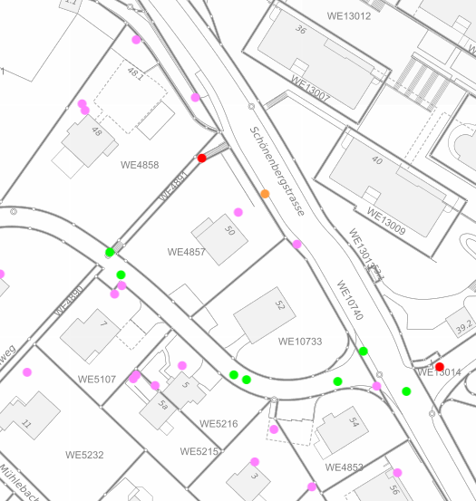
SEWAGE: MAINTENANCE
In this example, the condition of the manhole shafts is recorded, documented and evaluated. Damage, pollution or defects can be directly accessed and edited in the system and supplemented with photos or notes. Scheduled cleaning, maintenance or repairs can thus be efficiently coordinated and prioritized. Early detection of problems reduces emergency interventions, saves costs and increases the operational safety of the sewer system. This makes maintenance transparent, plannable and sustainable.
Source: City of Wädenswil
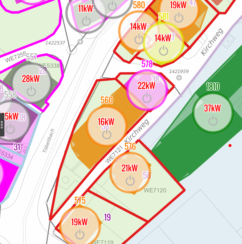
HEATING NETWORK: PLANNING
Wädenswil is already using waste heat and generating renewable heat, which is distributed to various consumers via district heating networks. The planning of the 'Energieverbund Wädenswil' is currently the focus of attention, which the city is realizing together with Energie 360°. The 'Energieverbund Wädenswil' is intended to supply numerous properties in the city center and in the Au with renewable heat from Lake Zurich in the future.
Source: City of Wädenswil
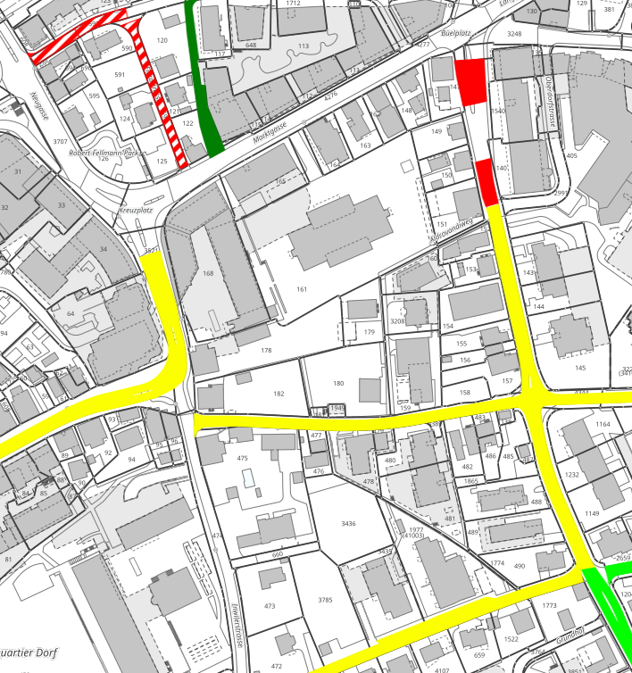
ROAD INFORMATION AND MAINTENANCE
Keep track of the condition and planned measures for your road network. All road sections, damage and maintenance work are recorded centrally and can be retrieved at any time. This enables you to plan repairs specifically, set priorities and significantly reduce administrative effort. Early detection of problems saves costs by reducing the number of emergency interventions and extends the service life of the roads.
Source: Geozug Ingenieure AG, Baar
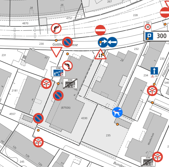
TRAFFIC SIGNS
Manage signal stands, signals and all associated documents in accordance with the Swiss Signalization Ordinance (SSV). Individual or user-defined traffic signs can also be integrated without any problems, so that the municipality can keep an overview of all signals and comply with the legal requirements. Maintenance, inspections and replacement measures can be planned in a targeted manner, which reduces administrative work.
Source: Geozug Ingenieure AG, Baar
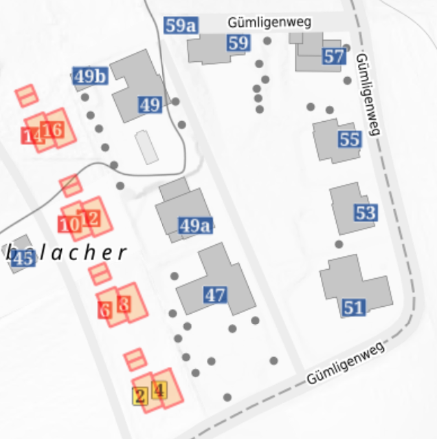
BUILDING AND HOUSING REGISTER (GWR)
The Swiss federal building and housing register (GWR) contains the most important basic data on buildings and dwellings. Each building and dwelling has a unique identification number (EGID) that is valid throughout Switzerland, as well as an address, municipality and canton. We have added the height to the data. Furthermore, the individual addresses are linked to the official GWR entry.
Added value: Exemplary integration, data download options (on request)
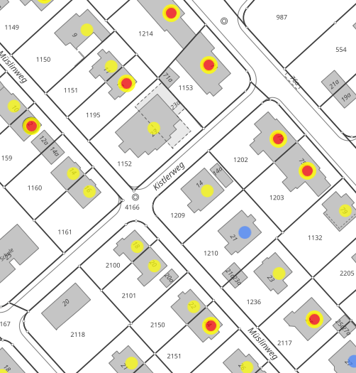
BUILDING HEATING SOURCES
The GWR contains information on construction projects, buildings, dwellings, building entrances and streets. The data layer 'Building: Heating sources' graphically illustrates (color) the energy/heat source of the most powerful heating system. Please note that the data is not up to date, as it is partly based on the 2000 census.
Added value: Exemplary integration, data download options (on request)
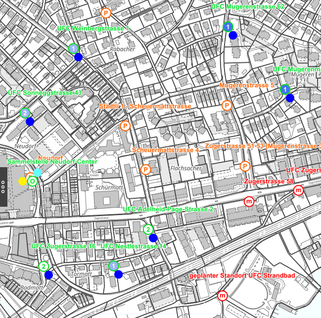
WASTE COLLECTION STATIONS
Capture, update and manage yourself - with minimal effort. The objects can also be recorded by field staff using a smartphone, with a click or by means of photos and GPS information. Post-processing can be conveniently done at the office on a PC. The recorded data can be expanded with documents, maintenance data, photos, etc. to create a comprehensive database.
Source: Geozug Ingenieure AG, Baar
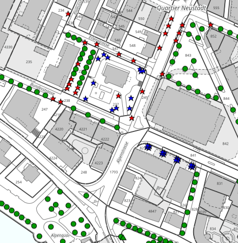
TREE CADASTRE
This module supports you in the professional management of your tree stock in public spaces. The trees are stored centrally and displayed clearly on a map. Regular inspections and maintenance measures are documented in a transparent manner - so the municipality can reliably fulfill its duty of care. The tree cadastre enables forward-looking maintenance planning, transparent budgeting and the long-term preservation of the municipal green spaces.
Source: Geozug Ingenieure AG, Baar
MAP+ MOBILE
MAP+ on tablets and smartphones
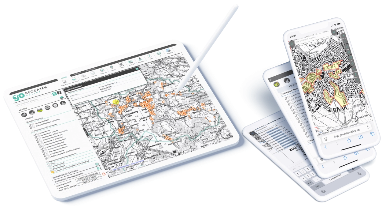
MAP+ is also a mobile WebGIS on smartphones or tablets, which provides maps and spatial data directly in the mobile browser. Users can retrieve, capture and edit location-based information in real time, for example via GPS-based positioning. But not only that: with sophisticated editing options, new objects can be added, existing geodata can be updated or attributes can be adjusted directly on site. This makes it particularly suitable for outdoor applications such as environmental monitoring, infrastructure maintenance or disaster management.
Image: Geozug Ingenieure AG, Baar
MAP+: Swiss WebGIS expertise that sets standards
MAP+ is one of the most widely used WebGIS solutions in Switzerland and stands for quality, scalability and practical experience.
- Successful in large cities: MAP+ is in productive use in numerous large cities such as Bern, Biel/Bienne, Chur, Davos, Fribourg, St. Gallen, Sion, Wädenswil, Zug, etc.
- Strongly established in municipalities: Thanks to the close collaboration with engineering offices, over 250 municipalities in Switzerland rely on MAP+ - efficient, reliable and future-proof.
- Cross-industry expertise: Whether forestry (GL, SZ, UR, VS), retail & telecommunications (Coop, Sunrise) or public infrastructure & safety (SBB, skiing resorts, Bern police, BFU, NSNW) - MAP+ impresses with specialized solutions for demanding applications.
Additional Information
- MAP+ Geoportals: www.mapplus.ch
- NODI as DaaS: Data as a Service: nodi.swiss
- TYDAC Inc.: www.tydac.ch
- OpenData offers: OpenData WIKI