NODI as DaaS: Data as a Service

NEWS

March 2026

With MAP+, you can realize individual applications in a short time - flexibly, efficiently and precisely tailored to your needs. Whether through our experienced team or independently by your specialist departments: MAP+ provides the technological basis for fast and sustainable solutions.

March 2025

Since December we were working on a major update of our complete data offering which included new graphics, new processes and new powerful servers with high speed NVMe SDD disks. This has speed up daily updates of surveying by factor five!

August 2025

The geo.admin WMS services have been updated in the geoadmin MAP+ application. The object query is now performed via the geo.admin API, so that the objects are highlighted. Aliases for all object queries have also been defined in four languages!

Februar 2024

It has been 33 years since TYDAC was founded. And it has been eight years since our last event for the 25th birthday, not least because of Covid. So it is more than time to get together!

OFFICIAL SURVEYING
Official surveying

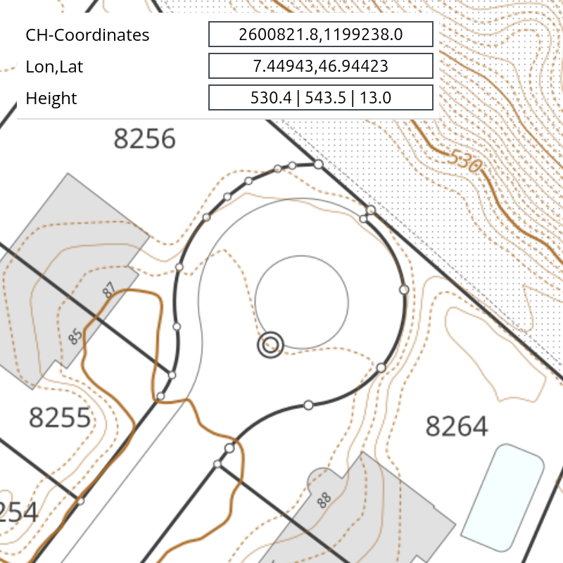
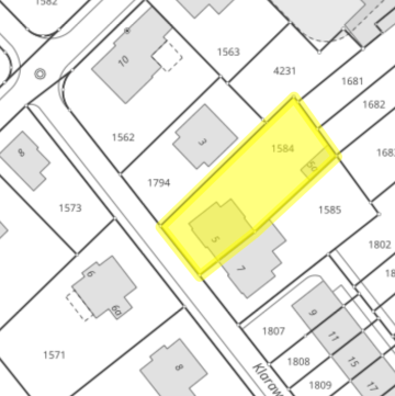
The main tasks of official surveying include, on the one hand, surveying land boundaries and updating these data. In this way, official surveying makes a significant contribution to securing land ownership. On the other hand, it forms the basis for almost all other geographic data and for many applications in business, administration, and private life.

PLR cadastre, landowners

The cadastre of public-law restrictions on property (PLR cadastre) is the reliable, official information system for the most important public-law restrictions on property. When querying a property, PLR information can be retrieved in 24 cantons. Landowners can be queried in 19 cantons.

Availability

The geodata of official surveying is available by canton as follows:

  • Original geodata in various formats (22): AG, AI, AR, BE, BL, BS, FR, GE, GL, GR, NW, OW, SH, SG, SO, SZ, TI, TG, UR, VS, ZG, ZH
  • WMS service from geodienste.ch (4): JU, LU, NE, VD
  • PLR cadastre (24, missing: FR, VD): AG, AI, AR, BE, BL, BS, GE, GL, GR, JU, LU, NE, NW, OW, SH, SG, SO, SZ, TI, TG, UR, VS, ZG, ZH
  • Landowners (19, missing: JU, LU, FR, NE, NW, OW, VD): AG, AI, AR, BE, BL, BS, GE, GL, GR, SH, SG, SO, SZ, TI, TG, UR, VS, ZG, ZH

Data preparation and integration by TYDAC

The geodata of the 22 cantons that provide source data and the 4 WMS cantons are seamlessly integrated as the base map for MAP+. Differences still exist in appearance and especially in query and search options:

  • 22 cantons with original data: basic information on parcels, links to the PLR cadastre and ownership information (where available), intersections with addresses, place names, land cover, land use, and building information (GWR). In addition: querying geodetic control points and boundary points, and searching by parcel number.
  • 4 WMS cantons: basic parcel information, links to the PLR cadastre and ownership information (where available), querying geodetic control points and boundary points.

Additional and derived data from official surveying

The following layers are available, except for the first two, only for the 22 cantons with original geodata:

  • Projected buildings
  • Projected parcels
  • Official surveying web services (WMS) in black-and-white, yellow (suitable for display in combination with aerial images), and dark mode
  • Land cover
  • Localization plan: streets and associated addresses
  • Federal building identifier EGID
Last update and processing results

The map below shows information on the latest data update by municipality. The data can be queried and contain information about the municipality itself as well as processing results from FME Flow, such as the number of processed objects and processing time (for example, Zürich: INTERLIS to PostGIS, around 2 million objects in 6.5 minutes).

Official surveying

FEDERAL DATA SOURCES

Our aim is not only to process and provide data, we want to provide better information about data and preconfigure available data as ready to use. This is one reason that TYDAC has compiled all WMS BGDI services into a MAP+ site. The BGDI (Bundes Geodaten-Infrastruktur = Federal Spatial Data Infrastrcture FSDI) supports the federal offices by setting up WMS services, well over 700. But until now, there was nowhere an overview and an application to view, search, analyze etc. this immense data load. The application lists all services subdivided by federal offices and allows the search by keywords - and that in four languages. And: under external maps, all web services of the cantons can be displayed (around 15'000 geoservices in total!). Ready to use configurations are available for MAP+ for all thesre services.

geoadmin.mapplus.ch

There is a wide choice of open data offers, however there is no centralized information platform that offers a quick overview. As we search ourselves all the time, we created that OpenData WIKI, a comprehensive compilation of sources and the best place to look for sources. The WIKI offers as well an overview and description of all WMS BGDI services grouped by federal department.

OpenData WIKI

Federal Data Sources processed by TYDAC

In addition to the Official Surveying we process data we think of as useful and add value to the datasets. As follows:

  • swisstopo: Topographic Landscape Model (TLM), Digital Elevation Models, Historic Aerial Images, Swiss Boundaries (Municipalities, Postal Codes)
  • Federal Office of Statistics: Federal Register of Buildings and Dwellings (Addresses, Heating Systems), municipalities infos & statistics
  • SwitzerlandMobile: outdoor sports summer and winter
  • Federal Office of Communication: mobile antennas locations
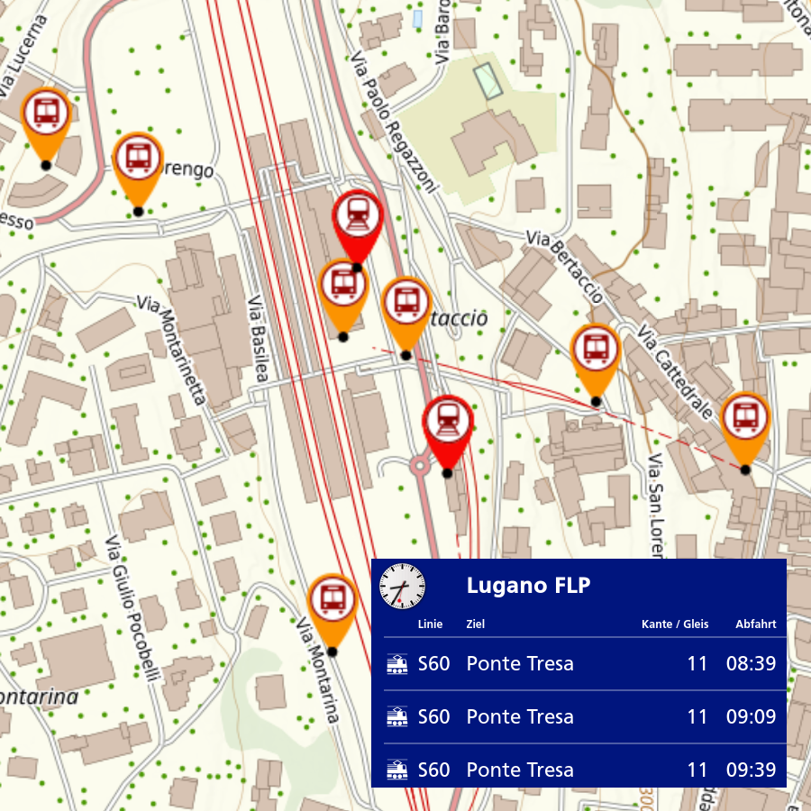
  • Federal Office of Transport: public transport service points
  • Federal Office of Culture: Iventory of Swiss heritage sites (ISOS)

ch.mapplus.ch

Examples

Here are a few examples of how TYDAC processes federal data and the specific added value this creates for users.

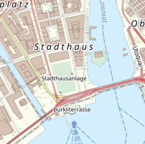
The swisstopo Topographic Landscape Model TLM contains objects that shape the landscape, e.g. buildings, roads and bodies of water and is basis for the production of the national maps. TYDAC produced on this basis its own map which can be used as a background map for many applications.
Added value: high quality map

swisstopo TLM by TYDAC

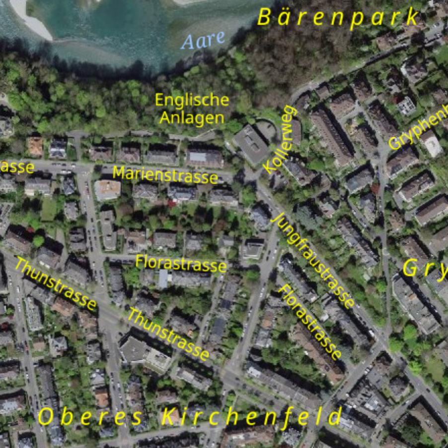
The swisstopo Topographic Landscape Model TLM contains as well all labels of the national maps. We setup labeling layers in black and in yellow. The yellow ones being very useful for orientation on aerial images.
Added value: useful orientation

swisstopo TLM Labels

swisstopo provides elevation data such as: swissALTI3D, a precise digital elevation model (ground altitude), swissSURFACE3D models all natural and man-made objects of the surface (such as buildings an trees). Available are derivative products such as slope and relief. TYDAC created itself some derivative products as slope in % and contours in up to 0.5m intervals. In addition swissALTI3D and swissSURFACE3D heights can be queried at any point in the landscape. This was the base for TYDAC to build a new 3D surface.
Added value:High quality 3D terrain

swisstopo DEM by TYDAC

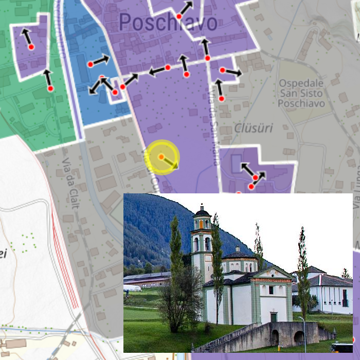
The Inventory of Swiss Heritage Sites (ISOS) designates and documents the most valuable sites of national importance. It makes it possible to understand the history and identity of sites and is thus an important basis for quality settlement development. Many offer a wide choice of stunning pictures, we integrated that in a way that you see the direction the photo ist taken.
Added value: unique integration of the available information and pictures

Inventory of Swiss Heritage Sites

This swisstopo image collection comprises around 500'000 analog aerial photos (color, color infrared or black and white images) and terrestrial images. Around 320'000 images are shown in the form of the image center coordinates, the respective covered floor segment (footprint) and with meta information. Our implementation shows information about the footprint, the image, a preview, a direct download link for the original image in TIFF format and a link to the zoomable full size image on map.geo.admin.ch.
Added value: better integration

swisstopo LUBIS: Aerial Images Database

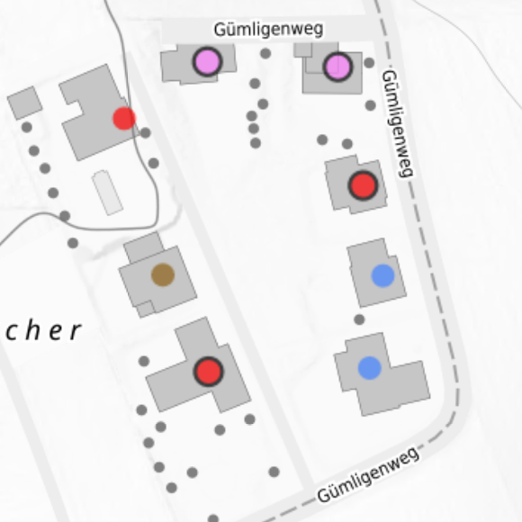
The GWR contains information on construction projects, buildings, apartments, building entrances and streets. The data shows heating system graphically (color) illustrates the energy/heat source of the most powerful heating system. It is important to note the status of the data, some of the data comes from the 2000 census.
Added value: better integration, data download capabilites (on request)

Heating System

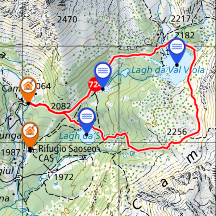
An exclusive combination of SwitzerlandMobility, swisstopo hiking trails, swisstopo maps, aerial images and TLM. In addition a wide choice of points of interest or information about einvironment and nature. Query the altitude at any location. Generate profiles and PDF reports for all types of routes.
Added value: unique integration of many datasets related to outdoor sports

SwitzerlandMobile - hike.mapplus.ch

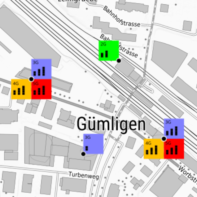
Cell sites: 2G, 3G, 4G or 5G? How strong are the antennas? Everything at a glance! The data comes from the Federal Office of Communications OFCOM and is updated weekly, therefore always up to date. It is also worth knowing: the individual symbols are composed of up to 124 parts!
Added value: cell type and strength at a glance

Mobile Cell Sites

We update the location and base data weekly and link it to the publicly available timetables of ÖV Plus. At a glance you see the next available connections. In combination with the Shared Mobility layer with a live view on available means of transport such as cars, bikes, scooters, etc. you have a unique view on your way to move with public transport.
Added value: unique data integration of different sources

Public Transport Service Points

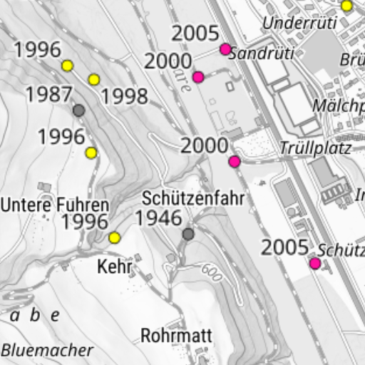
The Inventory of Swiss Heritage Sites (ISOS) designates and documents the most valuable sites of national importance. It makes it possible to understand the history and identity of sites and is thus an important basis for quality settlement development. Many offer a wide choice of stunning pictures, we integrated that in a way that you see the direction the photo ist taken.
Added value: unique integration of the available information and pictures

Inventory of Swiss Heritage Sites

Points of Interest

Touristic and thematic points of interest - from mountain peaks and glaciers to inns, museums and ski resorts.

Gastronomy

  • Restaurants Source: OpenStreetMap
    Coverage: Europe
    Updates: weekly
  • Mountain inns Source: SchweizMobil, Alpine club huts
    Coverage: Switzerland
    Updates: on demand
  • Fast Food Source: OpenStreetMap
    Coverage: Europe
    Updates: weekly
  • Bars Source: OpenStreetMap
    Coverage: Europe
    Updates: weekly
  • Breweries Source: OpenStreetMap
    Coverage: Europe
    Updates: weekly
  • Biergarten Source: OpenStreetMap
    Coverage: Europe
    Updates: weekly
  • Pubs Source: OpenStreetMap
    Coverage: Europe
    Updates: weekly
  • Night clubs Source: OpenStreetMap
    Coverage: Europe
    Updates: weekly
  • Cafés Source: OpenStreetMap
    Coverage: Europe
    Updates: weekly
  • Ice cream Source: OpenStreetMap
    Coverage: Europe
    Updates: weekly

Lodging

  • Hotels Source: OpenStreetMap
    Coverage: Europe
    Updates: weekly
  • Youth hostels Source: Swiss Hostels
    Coverage: Switzerland
    Updates: on demand
  • Backpackers Source: OpenStreetMap
    Coverage: Europe
    Updates: weekly
  • Sleep in the straw Source: Schlaf im Stroh
    Coverage: Switzerland
    Updates: on demand
  • Guesthouses Source: OpenStreetMap
    Coverage: Europe
    Updates: weekly
  • Motels Source: OpenStreetMap
    Coverage: Europe
    Updates: weekly
  • Campings Source: OpenStreetMap, TCS
    Coverage: Switzerland
    Updates: on demand
  • Mountain huts Source: SAC huts
    Coverage: Alps
    Updates: on demand
  • Shelters Source: OpenStreetMap
    Coverage: Alps
    Updates: on demand

Tourism, Sights

  • Tourist information Source: Switzerland Tourism
    Coverage: Switzerland
    Updates: on demand
  • Sights Source: SchweizMobil, OpenStreetMap
    Coverage: Switzerland
    Updates: weekly
  • Cultural property inventory Source: Federal Office for Civil Protection
    Coverage: Switzerland
    Updates: on demand
  • Parks Source: Swiss Parks
    Coverage: Switzerland
    Updates: on demand
  • Castles Source: OpenStreetMap
    Coverage: Switzerland
    Updates: weekly
  • Ruins Source: OpenStreetMap, Canton GR
    Coverage: Switzerland
    Updates: on demand
  • Monasteries Source: OpenStreetMap
    Coverage: Switzerland
    Updates: on demand
  • Caves Source: OpenStreetMap, SGH
    Coverage: Switzerland
    Updates: on demand
  • Viewpoints Source: TYDAC, SchweizMobil
    Coverage: Switzerland
    Updates: on demand

Retail

  • Supermarkets Source: OpenStreetMap
    Coverage: Europe
    Updates: weekly
  • Department stores Source: OpenStreetMap
    Coverage: Europe
    Updates: weekly
  • General stores Source: OpenStreetMap
    Coverage: Europe
    Updates: weekly
  • Kiosks Source: OpenStreetMap
    Coverage: Europe
    Updates: weekly
  • Bakeries Source: OpenStreetMap
    Coverage: Europe
    Updates: weekly
  • Butcheries Source: OpenStreetMap
    Coverage: Europe
    Updates: weekly
  • Pharmacies Source: OpenStreetMap
    Coverage: Europe
    Updates: weekly

Swiss Post Access Points

  • Branches Source: Swiss Post
    Coverage: Switzerland
    Updates: weekly
  • Service Points Source: Swiss Post
    Coverage: Switzerland
    Updates: weekly
  • Post 24 Source: Swiss Post
    Coverage: Switzerland
    Updates: weekly
  • PostFinance Source: Swiss Post
    Coverage: Switzerland
    Updates: weekly
  • Postomats Source: Swiss Post
    Coverage: Switzerland
    Updates: weekly

Public Entities, Administration

  • Playgrounds Source: OpenStreetMap
    Coverage: Switzerland
    Updates: weekly
  • Indoor playgrounds Source: OpenStreetMap
    Coverage: Switzerland
    Updates: on demand
  • Kindergartens Source: OpenStreetMap
    Coverage: Switzerland
    Updates: weekly
  • Primary schools Source: OpenStreetMap, Cantons
    Coverage: Switzerland
    Updates: on demand
  • Secondary schools Source: OpenStreetMap, Cantons
    Coverage: Switzerland
    Updates: on demand
  • Vocational schools Source: OpenStreetMap, Cantons
    Coverage: Switzerland
    Updates: on demand
  • High schools Source: OpenStreetMap, Cantons
    Coverage: Switzerland
    Updates: on demand
  • Universities, ETH Source: swissuniversities
    Coverage: Switzerland
    Updates: on demand
  • Hospitals Source: OpenStreetMap, Cantons
    Coverage: Switzerland
    Updates: on demand
  • Retirement homes Source: OpenStreetMap, CURAVIVA
    Coverage: Switzerland
    Updates: on demand
  • Churches Source: OpenStreetMap
    Coverage: Switzerland
    Updates: weekly
  • Police Source: OpenStreetMap, Cantons
    Coverage: Switzerland
    Updates: on demand
  • Embassies / Consulates Source: FDFA
    Coverage: World
    Updates: on demand

Culture

  • Cinemas Source: OpenStreetMap
    Coverage: Switzerland
    Updates: weekly
  • Theatres Source: OpenStreetMap, Cultural Office
    Coverage: Switzerland
    Updates: on demand
  • Museums Source: VMS, OpenStreetMap
    Coverage: Switzerland
    Updates: on demand
  • Libraries Source: OpenStreetMap, BIS
    Coverage: Switzerland
    Updates: on demand
  • Architecture Highlights Source: TYDAC
    Coverage: Switzerland
    Updates: on demand
  • Wakker Prize Source: Swiss Heritage Society
    Coverage: Switzerland
    Updates: yearly

Public Transport (CH)

  • Stops Source: OpenStreetMap, SBB
    Coverage: Switzerland
    Updates: weekly
  • Rail network Source: SBB
    Coverage: Switzerland
    Updates: quarterly
  • Public transport travel times Source: SBB HAFAS
    Coverage: Switzerland
    Updates: weekly
  • Cable cars Source: SBS, OpenStreetMap
    Coverage: Switzerland
    Updates: on demand
  • Shipping Source: OpenStreetMap, SBS
    Coverage: Switzerland
    Updates: seasonal
  • Airports Source: OpenStreetMap
    Coverage: Switzerland
    Updates: on demand
  • Car rental Source: OpenStreetMap
    Coverage: Switzerland
    Updates: weekly
  • Shared Mobility Source: OpenStreetMap, providers
    Coverage: Switzerland
    Updates: weekly
  • Rail noise Source: FOEN
    Coverage: Switzerland
    Updates: on demand

Public Transport Europe

  • Train stations EU Source: OpenStreetMap
    Coverage: Europe
    Updates: weekly
  • Tram Source: OpenStreetMap
    Coverage: Europe
    Updates: weekly
  • Bus Source: OpenStreetMap
    Coverage: Europe
    Updates: weekly
  • Metro Source: OpenStreetMap
    Coverage: Europe
    Updates: weekly
  • Shipping EU Source: OpenStreetMap
    Coverage: Europe
    Updates: on demand
  • Bike rental EU Source: OpenStreetMap
    Coverage: Europe
    Updates: weekly

Private Transport

  • Parking Source: OpenStreetMap, cities
    Coverage: Switzerland
    Updates: weekly
  • Gas stations Source: OpenStreetMap
    Coverage: Europe
    Updates: weekly
  • EV charging CH Source: OpenStreetMap, swissemobile
    Coverage: Switzerland
    Updates: weekly
  • EV charging EU Source: OpenStreetMap
    Coverage: Europe
    Updates: weekly
  • Service areas Source: OpenStreetMap
    Coverage: Switzerland
    Updates: on demand
  • Mountain passes Source: SchweizMobil
    Coverage: Alps
    Updates: on demand
  • Customs offices Source: BAZG
    Coverage: Switzerland
    Updates: on demand
  • Road noise Source: FOEN
    Coverage: Switzerland
    Updates: on demand

Services

  • Banks Source: OpenStreetMap
    Coverage: Switzerland
    Updates: weekly
  • ATMs Source: OpenStreetMap
    Coverage: Switzerland
    Updates: weekly
  • Fountains Source: OpenStreetMap, TYDAC
    Coverage: Switzerland
    Updates: on demand
  • Benches Source: OpenStreetMap, TYDAC
    Coverage: Switzerland
    Updates: on demand
  • Recycling collection points Source: OpenStreetMap
    Coverage: Switzerland
    Updates: weekly
  • Public toilets Source: OpenStreetMap
    Coverage: Switzerland
    Updates: weekly
  • Defibrillators (AED) Source: OpenStreetMap
    Coverage: Switzerland
    Updates: weekly

Sport, Leisure

  • Vita parcours Source: SchweizMobil
    Coverage: Switzerland
    Updates: on demand
  • Hiking boards Source: SchweizMobil, TYDAC
    Coverage: Switzerland
    Updates: on demand
  • Hiking & mountain passes Source: SchweizMobil
    Coverage: Switzerland
    Updates: on demand
  • Fireplaces Source: TYDAC, OpenStreetMap
    Coverage: Switzerland
    Updates: on demand
  • Via Ferrata Source: TYDAC, SchweizMobil
    Coverage: Alps
    Updates: on demand
  • Swimming Source: OpenStreetMap
    Coverage: Switzerland
    Updates: seasonal

Administrative Areas

  • Cantonal borders Source: swisstopo
    Coverage: Switzerland
    Updates: on demand
  • Municipal borders Source: swisstopo, Cantons
    Coverage: Switzerland
    Updates: quarterly
  • Municipalities Source: FSO, swisstopo
    Coverage: Switzerland
    Updates: quarterly
  • Postal codes Source: Swiss Post
    Coverage: Switzerland
    Updates: quarterly
  • Regions Source: FSO
    Coverage: Switzerland
    Updates: on demand
  • Districts / Circles Source: FSO, Cantons
    Coverage: Switzerland
    Updates: on demand
  • Municipalities EU Source: Eurostat
    Coverage: Europe
    Updates: yearly

Nature and Landscape

  • Mountain peaks Source: swisstopo TLM
    Coverage: Switzerland
    Updates: if needed
  • Mountain lists (SAC) Source: TYDAC
    Coverage: Switzerland
    Updates: if needed
  • Lakes Source: swisstopo, FOEN
    Coverage: Switzerland
    Updates: if needed
  • Waterfalls Source: TYDAC, Alternatives Wandern
    Coverage: Switzerland
    Updates: if needed
  • Glaciers Source: TYDAC, swissinfo
    Coverage: Switzerland
    Updates: if needed
  • Gorges Source: TYDAC, swissinfo
    Coverage: Switzerland
    Updates: if needed
  • Wetlands Source: TYDAC, swissinfo
    Coverage: Switzerland
    Updates: if needed